

Google expands experimental access to the Geospatial Reasoning agent and adds analysis of users’ own data
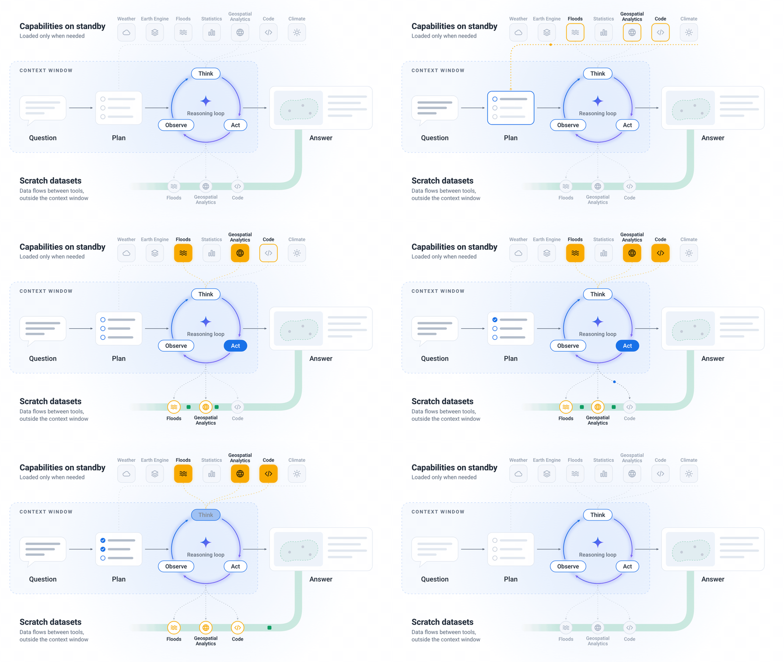
Google is expanding early access to the Geospatial Reasoning agent through the Ask Google Earth service and the A2A interface. The API allows users to add their own data in CSV and GeoJSON formats or from cloud tables and combine it with geospatial models and catalogs.
Google is expanding experimental access to the Geospatial Reasoning agent through the Ask Google Earth service and the Agent-to-Agent (A2A) service. It is inviting additional partners to join early access. Users can now use the API to add their own data in CSV and GeoJSON formats or from cloud tables and request analyses that combine it with Google Earth AI models and catalogs.
The agent creates an analytical plan before complex operations. According to Google, it also selects alternative datasets when local coverage is insufficient and processes large map layers in a separate working environment. Responses display both the plan and the data sources used so that experts can verify assumptions or replace datasets.
Google also announced the integration of Google Dataset Search to search more than 100 million public datasets and TimesFM to estimate current conditions and produce forecasts. According to the company, these capabilities use over 70 geospatial tools. The company says its own evaluation in the Earth AI Technical Report shows the benefits of specialized tools and advance planning, particularly for complex, multi-step analyses.
Why it matters
The expansion allows participating partners to try geospatial analyses that combine data on their own locations with global data. Potential practical uses include site selection, resilience planning for crises and public health analyses. Access remains experimental; the evaluation results are reported by Google itself.
What was added since the original report
Verified updates
-
Experimental access is expanding through Ask Google Earth and the A2A service.; The API allows users to add their own data in CSV and GeoJSON formats or from cloud tables.; The agent combines user-provided data with Earth AI models and catalogs.; The agent creates an analytical plan before complex operations.; Responses display the plan and the data sources used.
- Experimental access is expanding through Ask Google Earth and the A2A service.
- The API allows users to add their own data in CSV and GeoJSON formats or from cloud tables.
- The agent combines user-provided data with Earth AI models and catalogs.
- The agent creates an analytical plan before complex operations.
- Responses display the plan and the data sources used.
Two audiences, two different impacts
What this means
For individuals
An analyst with early access can review the data used and the analytical plan behind a response to assess the assumptions underlying a particular result.
For a business
Organizations with early access can use the API to incorporate their own location data into multi-step analyses alongside Google Earth AI models and catalogs.
ProcessesCheck the original
Event sources
only one source so far · 1 publisher, 0 independent. We count feeds from the same owner only once.